


Kent Precinct 05-001, Kent County, Maryland
About
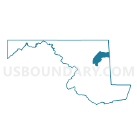
Outline

Summary
| Unique Area Identifier | 592610 |
| Name | Kent Precinct 05-001 |
| County | Kent County |
| State | Maryland |
| Area (square miles) | 96.87 |
| Land Area (square miles) | 28.02 |
| Water Area (square miles) | 68.85 |
| % of Land Area | 28.93 |
| % of Water Area | 71.07 |
| Latitude of the Internal Point | 39.08752820 |
| Longtitude of the Internal Point | -76.23136310 |
Maps


Graphs
Select a template below for downloading or customizing gragh for Kent Precinct 05-001, Kent County, Maryland


Neighbors
Neighoring Voting District (by Name) Neighboring Voting District on the Map
- Anne Arundel Precinct 03-011, Anne Arundel County, MD
- Anne Arundel Precinct 03-015, Anne Arundel County, MD
- Baltimore County Precinct 15-021, Baltimore County, MD
- Baltimore County Precinct 15-022, Baltimore County, MD
- Kent Precinct 06-001, Kent County, MD
- Kent Precinct 07-001, Kent County, MD
- Queen Anne's Precinct 03-002, Queen Anne's County, MD
- Queen Anne's Precinct 04-001, Queen Anne's County, MD
- Queen Anne's Precinct 04-004, Queen Anne's County, MD
- Queen Anne's Precinct 05-001, Queen Anne's County, MD
- Queen Anne's Precinct 05-003, Queen Anne's County, MD
Top 10 Neighboring County Subdivision (by Population) Neighboring County Subdivision on the Map
- District 15, Baltimore County, MD (104,763)
- District 3, Anne Arundel County, MD (74,413)
- District 4, Kent Island, Queen Anne's County, MD (18,157)
- District 5, Queenstown, Queen Anne's County, MD (8,812)
- District 3, Centreville, Queen Anne's County, MD (8,524)
- District 5, Edesville, Kent County, MD (2,618)
- District 6, Fairlee, Kent County, MD (1,900)
- District 7, Pomona, Kent County, MD (1,222)
Top 10 Neighboring Place (by Population) Neighboring Place on the Map
Top 10 Neighboring Unified School District (by Population) Neighboring Unified School District on the Map
- Baltimore County Public Schools, MD (805,029)
- Anne Arundel County Public Schools, MD (537,656)
- Queen Annes County Public Schools, MD (47,798)
- Kent County Public Schools, MD (20,197)
Top 10 Neighboring State Legislative District Lower Chamber (by Population) Neighboring State Legislative District Lower Chamber on the Map
- State Legislative District 36, MD (137,167)
- State House Districts not defined (Anne Arundel County), MD (0)
- State House Districts not defined (Baltimore County), MD (0)
- State House Districts not defined (Queen Anne's County), MD (0)
- State House Districts not defined (Kent County), MD (0)
Top 10 Neighboring State Legislative District Upper Chamber (by Population) Neighboring State Legislative District Upper Chamber on the Map
- State Senate District 36, MD (137,167)
- State Senate Districts not defined (Anne Arundel County), MD (0)
- State Senate Districts not defined (Baltimore County), MD (0)
- State Senate Districts not defined (Queen Anne's County), MD (0)
- State Senate Districts not defined (Kent County), MD (0)
Top 10 Neighboring 111th Congressional District (by Population) Neighboring 111th Congressional District on the Map
Top 10 Neighboring Census Tract (by Population) Neighboring Census Tract on the Map
- Census Tract 9504, Kent County, MD (3,117)
- Census Tract 9505, Kent County, MD (2,623)
- Census Tract 4519, Baltimore County, MD (2,445)
- Census Tract 9902, Queen Anne's County, MD (0)
- Census Tract 9900, Queen Anne's County, MD (0)
- Census Tract 9900, Anne Arundel County, MD (0)
- Census Tract 9900, Kent County, MD (0)